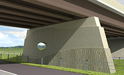
By its nature, the boundary exhibits topographic asymmetryn — the rolling terrain of the Loess Hills looms in stark contrast to the flat Missouri River floodplain. This contrast places emphasis on the unique beauty of the Loess Hills. The bridges respond to this natural condition by exhibiting asymmetry in their basic massing. An exaggerated berm feature occurs only at the east end of the bridges. The landform’s shape recalls features indigenous to the nearby loess geology. The west end of the superstructure is purposefully made to disappear without embellishment into the western slope, further reflecting the contrast found in the surroundings.
 The leading bridge piers encountered by both north- and southbound travelers have been extended into the approach ditches and rise as hills from the landscape to support the structures. The piers are attractively shaped, textured and colored to evoke images of rolling, undulating hills. There is more asymmetry in the transverse section of the bridges as viewed by motorists passing underneath, which reiterates the conditions evident in the greater landscape.
A split-second surprise — as northbound I-29 traffic emerges from beneath the first bridge, an oculus carved through the westbound U.S. 34 pier momentarily frames the traveler’s view. That view is precisely focused on the Loess Hills horizon one mile northeastward, and calls resolute attention to the natural environment that inspires and enlightens the design of the bridges.
This project represents an opportunity to celebrate the land, and to showcase Iowa’s revered Loess Hills with a directness and economy appropriate for high speed viewing. The design seeks to blur the boundary between the bridges and the land in commemoration of a beloved and remarkable place — The Loess Hills of Iowa.
Return to the Featured Bridges page.