MACH software is the next generation 3CS (Collaborative Command and Control Software) application. With MACH, national model agencies are able to easily cooperate during daily activities and emergency events. From the vehicle to the dispatch center, MACH leads the way.
Features
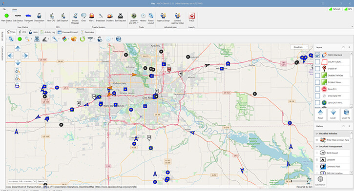
Real-time data: Know your surroundings with real-time data.
- Intuitive interface to see and communicate with all MACH software users instantly.
- Unit, incident, and alert locations.
- Local establishment and address searching.
- Satellite views of unfamiliar structures.
Real-time mapping: Experience up-to-date mapping in the vehicle, office, and command center.
- Integrated Google Maps™ provide familiar imagery.
- Cached or saved maps for low-bandwidth areas.
Custom maps: Increase your awareness with custom map features.
- Custom map zones for easy dispatching - jurisdiction, county, municipal boundaries, etc.
- Custom map markers that can be placed by officers in the field.
- Custom map layers for mile markers, crime hotspots, construction projects, and more - obtain KMZ/KML files from your local or state GIS systems.
Instant messaging: Stay informed with instant messaging and multiunit chat sessions.
- Alerts available by proximity or invite including – amber, missing person, officer needs assistance, stolen vehicle, wanted person, weather advisory.
- Incidents available by proximity or invite including – accident, domestic, fire, homeland security, medical, natural disaster.
- Broadcasts as one-way or one-time communications including – central, internal agency, law enforcement sensitive.
Cross-agency interoperability: Cooperate with your neighboring public safety agencies.
- Participate in cross-agency sessions at the federal, state, county, and local level.
- Coordinate with law enforcement, fire, emergency medical services, and highway authorities.
- Decide when and how your units communicate with units from other agencies.
NCIC/NLETS searches: Don't bother dispatch. Run searches directly from your computer.
- Search for information on persons, vehicles, guns, and other articles.
- Get driver license photos from the Iowa DOT.
Silent dispatching: Reduce radio chatter. Dispatch silently and effectively.
- Observe an aerial view of incident locations and nearby units.
- Locate the most qualified unit with point-and-click map filter and search tools.
- Dispatch units with location- and invitation-based sessions.