Process of Traffic Counting
The Iowa DOT uses manual traffic counters, portable tube counters and Continuous Count Stations (CCS) throughout the state to collect traffic data used in the calculation of Annual Average Daily Traffic (AADT). Traffic volume is aggregated based on the FHWA's 13 vehicle category classification for the primary highway system or as a summed total for non-primary and estimated roads.
Traffic counts are recorded at a specific point on the roadway. This point is referred to as a count station or site. The point often represents the characteristics of a road segment. For example, a count location is often assigned to a segment of road. The definition of a segment varies by State; here it refers to a section of roadway defined by the State. Since collecting traffic data is not feasible on every possible point within a segment, traffic data collected and representing a point on a segment is extrapolated to represent the entire segment.
Annual & Monthly Reports
In addition to collecting traffic volume data, the Iowa DOT also compiles by month and by year and submits these reports to the Federal Highway Administration. These reports provide insight on any changes that may take place over time with the usage of the roadways. The information contained in the reports is useful in understanding trends as it relates to growing, consistent or declining volumes of traffic.
The Iowa Department of Transportation’s Systems Planning Bureau, in cooperation with the Federal Highway Administration, also prepares traffic reports for the volume of traffic on the primary road system in the form of an annual traffic book.
How to View Traffic Information
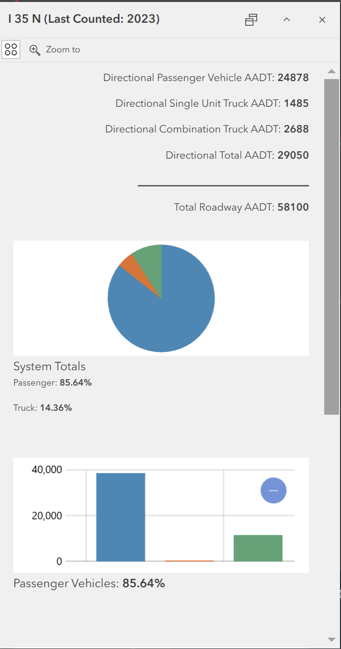
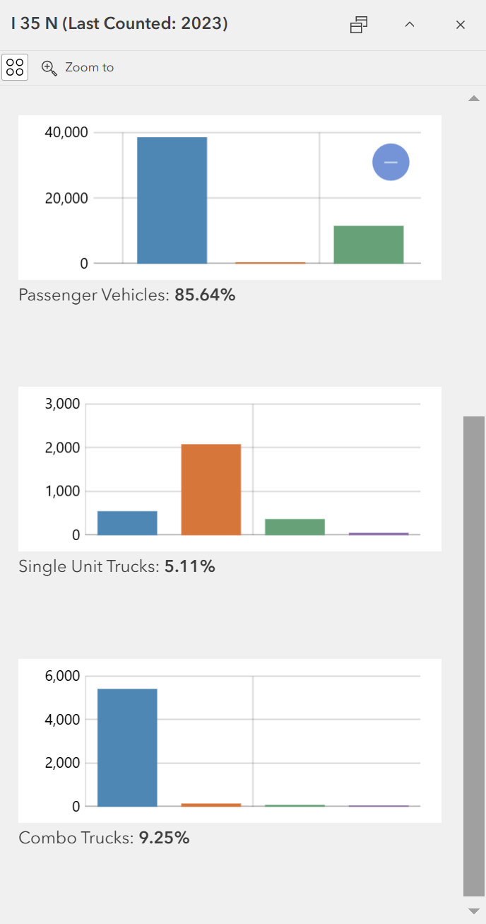
Traffic information is contained within pop-ups in the web maps. To view a pop-up, click on any roadway segment to see additional roadway information. If viewing a segment on the primary highway system, a breakdown of each individual vehicle classification will be shown. To view more information, hover your mouse pointer over one of the graphs. Divided primary highways will show directional traffic volumes as well as the total roadway volume in the pop-up.
The non-primary and estimated roadway segments will only contain the overall AADT value, street name and the entity that has jurisdiction of the road. Some local jurisdictions can include counties and cities but some may also have another institution like a college or university that is responsible for it.
|
|
|---|
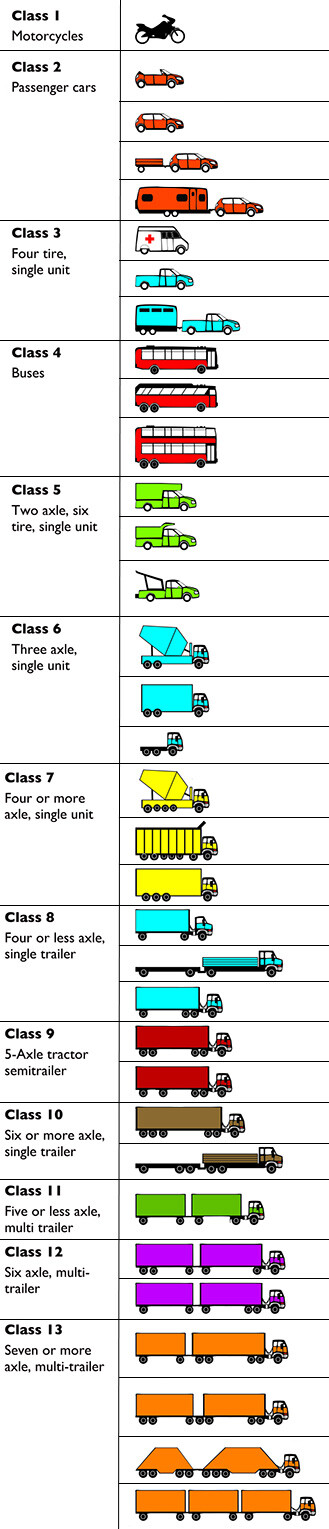
Vehicle Classification
For the primary highway system, the FHWA vehicle classification system separates vehicles into categories depending on whether they carry passengers or commodities.
- Passenger vehicles (classes 1 - 3)
- Single unit trucks (classes 4 - 7)
- Combination trucks (classes 8 - 13)
Note: For the purposes of this web map, classes 11 - 13 are combined into a single category named "Multiple Trailers."
| Term | Definition |
|---|---|
| Cars, pickups, and vans | All two-axle, four-tire vehicles that primarily carry passengers |
| Motorcycles | All two- or three-wheeled motorized vehicles |
| Single unit two-axle | All vehicles on a single frame, including trucks, camping and recreational vehicles, motor homes, etc., having two axles and dual-rear wheels |
| Single unit three-axle | All vehicles on a single frame, including trucks, recreational vehicles, motor homes, etc., having three axles |
| Single unit four-axle | All trucks on a single frame with four or more axles |
| Bus | All vehicles manufactured as traditional passenger-carrying buses with two axles and six tires, or three or more axles |
| Combination four-axle | All vehicles with four or less axles consisting of two units, one of which is a tractor or straight truck power unit |
| Combination five-axle | All five-axle vehicles consisting of two units, one of which is a tractor or straight power unit |
| Combination six-axle | All vehicles with six or more axles consisting of two units, one of which is a tractor or straight truck power unit |
| Double bottom | All vehicles with six or more axles consisting of three units, one of which is a tractor or straight truck power unit |