- Year constructed: 1958
- Bridge type: Mild Reinforced Cast-in-Place Box Beam
- National Register of Historic Places status: Eligible
- Length: 502 feet
- Width: 28 feet
- Spans: 5
- FHWA: 023780
- Jurisdiction: Iowa DOT
- Location: Westbound U.S. 20 south of Dyersville over N fork Maquoketa River, 0.6 mile west of Jct. Iowa 136, Section 6, T88N-R2W (Dodge Township)
Details
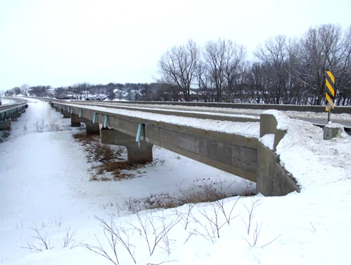
This 502' by 28' bridge carries westbound U.S. 20 south of Dyersville. Prestressed concrete box girders support cast-in-place concrete decking. The five-span bridge has a three 109' center spans and 85'6" approach spans. The concrete piers have untreated wood piles; while the abutments have creosoted wood piles. A large bend in the Maquoketa River was channelized for bridge crossing. The structure was designed by the ISHC in May 1957.
As early as 1955, the Iowa Highway Commission proposed to relocate U.S. Highway 20 between Dyersville and Center Grove, located just west of Dubuque. The 22 mile long highway was located south of the existing Highway 20 bypassing the towns of Centralia, Epworth, and Farley (Telegraph-Herald Aug. 16, 1959:1). The bypass was designed to be a safer route than the narrow Highway 20 that had numerous dangerous curves. The eastern 3.6 miles of the route had four lanes of traffic; while the remaining route had two lanes. John P. Abrahamson Construction Company of Des Moines and J. C. Costigan Construction Company of Elkader constructed the bridges along the bypass route (Telegraph-Herald Dec. 22, 1957:1). By July 20, 1958, all of the bridges along the bypass were complete (Telegraph-Herald July 20, 1958:28). The highway was opened to traffic on August 31. 1959 (Cedar Rapids Gazette, August 31, 1959:9). At the time of completion, extension of the four lane route into Dubuque was already being planned The U.S. Highway 20 Bridge was included for Phase II evaluation under Criterion A as it was a new bridge built as part of a relocation of U.S. Highway 20 through Dubuque County. Registration requirements outlined in the MPD state that a bridge can be eligible under Criterion A if it established a new highway transportation corridor, and can be shown to have been the direct cause of significant development or changes in land use.
The U.S. 20 relocation does appear to have been the direct cause of significant development or major changes in land use in three towns along the route: Epworth, Farly, and Dyersville. While the highway certainly changed the land use of property in the path of its construction, it appears that the artery substantially increased each town by approximately 30%. All three towns experienced residential growth, including a large residential development on the north side of the highway in Dyersville. Aerial photographs from the 1950s, 1960s, and 1990s show large commercial developments on the south side of Dyersville, as well as a high school, medical center, and golf course. A seminary was also built in Epworth after the highway was relocated. Given these facts, LBG concludes that the U.S. Highway 20 Bridge does meet registration requirements under Criterion A as part of a new highway corridor that was the direct cause of significant development in West Burlington. The bridge does not meet any of the other registration requirements for Type 505 bridges.
Areas Served
- Dubuque