Attention: Text Scams Details Fraudulent text messages appearing to come from the Iowa DOT or DMV are targeting recipients with false claims of unpaid traffic violations or tolls. Learn more about the scam
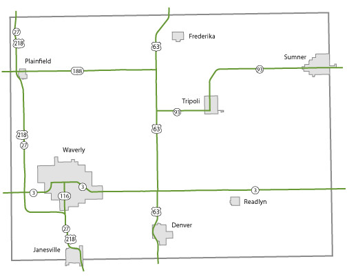
Bremer County Maps Topics: County Maps List items for Bremer County Maps City and County Maps Bremer color map (1.59 MB) Archived .pdf Bremer black/white map (1.56 MB) Archived .pdf Bremer DGN MapBremer DWG Map City list County list City traffic maps County traffic maps City Maps in Bremer County Denver mapFrederika mapJanesville mapPlainfield mapReadlyn mapSumner mapTripoli mapWaverly map Federal Functional Classification Maps Bremer County FFC map (2.09 MB) .pdf Waverly FFC map (1.56 MB) .pdf Urban area FFC list County FFC list Farm to Market Maps Bremer County FM map (840.29 KB) .PDF County FM list Help Get help printing PDFs, and find more city and county map information on the Help with Maps page. Areas Served Bremer Secondary Navigation Menu All Counties
Topics: County Maps List items for Bremer County Maps City and County Maps Bremer color map (1.59 MB) Archived .pdf Bremer black/white map (1.56 MB) Archived .pdf Bremer DGN MapBremer DWG Map City list County list City traffic maps County traffic maps City Maps in Bremer County Denver mapFrederika mapJanesville mapPlainfield mapReadlyn mapSumner mapTripoli mapWaverly map Federal Functional Classification Maps Bremer County FFC map (2.09 MB) .pdf Waverly FFC map (1.56 MB) .pdf Urban area FFC list County FFC list Farm to Market Maps Bremer County FM map (840.29 KB) .PDF County FM list Help Get help printing PDFs, and find more city and county map information on the Help with Maps page. Areas Served Bremer Secondary Navigation Menu All Counties
Help Get help printing PDFs, and find more city and county map information on the Help with Maps page.