Whenever there is a crash, tensions can run high for everyone involved. With “Safety First” and “People Matter” as two of our core values, doing whatever we can to relieve some of that tension is a high priority.
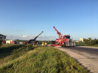
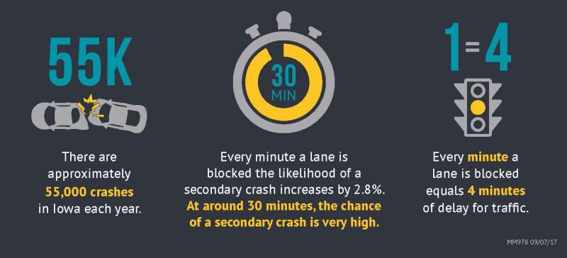
No one likes to sit in traffic waiting for lanes to be cleared after a crash. Not only is it annoying, but it can also be very dangerous. Jim Armstrong, an engineer in our Systems Operations Division quotes a national statistic that for every minute a lane is closed and traffic backs up, the risk of a second crash in the same area goes up 2.8 percent.
The choice to detour traffic is not an easy one for law enforcement and our field forces. One reassurance that we can give them is to have pre-planned routes where traffic can safely be diverted when needed to relieve traffic backups.
The idea of establishing potential detour routes ahead of time in case traffic needs to be diverted is not new. District and garage staff know their areas well and know what routes can and can’t be used to move traffic when something happens on a main route. These informal diversion routes were a good first step, but planning for and formalizing these routes, commonly referred to as Traffic Incident Management or TIM plans, ensures that those people who are determining detours have the most up-to-date information.

Armstrong said, “Formalizing the TIM plans and then reviewing them every year will make sure the detour routes, responsibilities, contacts, and information in the TIM plan have not changed. We also check to make sure there are no issues with construction or other closures on the TIM detour. Without these plans, the leader at the crash scene may inadvertently put interstate traffic on county roads or bridges that can’t safely handle that amount of traffic.”
To begin formalizing the plans, three consultants were hired in 2017. They developed 900+ routes in a format that could be printed and distributed. “These plans were a good start, but each consultant had a different format, so they weren’t consistent across the state. They were also just files on a server, so when updates were made it was tough to keep the most current versions in the hands of the people who needed them.”
Armstrong said, “Currently, the main users of these plans are in the Traffic Management Center. Working with law enforcement and our field people and using these plans, we can find a safe way to reduce the amount of traffic that backups near an incident. That not only makes the road safer for drivers, but also for the first responders on the scene.”
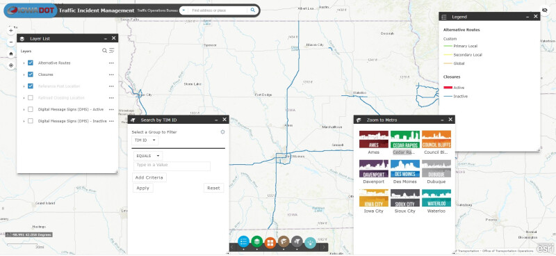
A few years ago, we hired the Institute for Transportation at Iowa State University to develop an online dashboard and interactive maps to make the most current diversion routes more accessible. The site includes route files that can be downloaded. This project ties into one of our five-year goals to “grow innovation.”
Armstrong said the project is ongoing to standardize and update all diversion routes, with about 300 currently completed. “We are taking a look at each route to make sure it is correct before we put it into the system. Because these routes often include county roads, we’re working with local multi-disciplinary safety teams and our own field staff to map out the best routes.”
The plans only work well if there is great communication between everyone involved in developing the plans and our field forces. He said, “We need to keep those lines of communication wide open within the Iowa DOT and then we need to make sure the county engineers know these plans so if they have construction projects on a specific road that we have designated as a diversion route, they will let us know and we can adjust.”
By the end of the summer, Armstrong anticipates all necessary diversion routes will be in the dashboard. “Once that is done,” he said, “We’ll be able to update them electronically and everyone will be able to access the latest version from any device. That should make the decision to divert traffic much easier for those at the scene.”
When a TIM Plan is activated all of the detour routes are shown as a layer in MACH, the mapping software used by law enforcement on the laptops in their patrol units. Armstrong said, “This is going to be a major step forward to get everyone more comfortable that it is safe to detour traffic and where those detours should happen. In the future, there are plans to automate messages that go to dynamic message signs along the route that will automatically help divert traffic when there is an incident, and a TIM Plan is activated. We’re excited about these safety innovations.”
When there is a crash, minutes matter to keep both travelers and first responders safe. Please go to our Traffif Incident Management page to check out these diversion routes. If you have questions or find issues, contact Jim at james.armstrong@iowadot.us.