
Content Information
On this page...
Ditches are described as having a depth that is measured from profile grade and bottoms that typically have a normal cross slope of 0%. The normal ditch depth for rural highways is 5 feet and the normal ditch width is 10 feet. For divided roadways, the median ditch depth is 4 feet, as defined by ‘M’ in Figure 1 below.
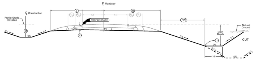
Figure 1: Typical cross section of a normal ditch.
Back to topDitching Guidelines
Consider the following guidelines when determining ditching for a project:
The proposed drainage layout should conform to the existing drainage pattern.
Avoid crossing ridge lines with ditch grades whenever possible.
Legal problems can arise when drainage is taken from its existing drainage area and diverted into another drainage area
Consider impacts to underground utilities.
When water is draining from a cut section to a fill section, consideration should be given to carrying the water to the draw in a special ditch to contain flow and avoid silt accumulating in an adjacent field. Refer to Road Design Detail 4204 for more information on special ditches.
If adjusting ditch width, always make width increase with the direction of flow. Erosion may occur if ditch width decreases with increasing flow.
Limit the length of variable ditches used to tie into structures to no more than 100 feet, except in isolated cases.
Careful consideration should be given to ditching in critical areas, e.g. front yards, etc.
‘V’ ditches are less desirable than flat bottom ditches due to erosive tendencies; however, they can be used where site conditions are restrictive.
When the backslope is 10 feet or higher, an intercepting ditch may be necessary. Refer to Section 3G-2 and Road Design Details 4101 and 4102 for more information regarding intercepting ditches.
If the backslope exceeds 25 feet, or if foreslope or backslope stability is required, refer to Road Design Detail 4104 and Section 3J-1.
Review ditching for possible letdown structures when roadway grade exceeds 5%.
Consider the following guidelines relating to the use of ditch grades:
Refer to Section 20D-2 for guidance on proper naming conventions for ditch grades in design files.
Compute ditch grades to tenths of a percent and elevations to tenths of a foot.
Minimum acceptable ditch grades range from 0.2% to 1.0%.
Desirable ditch grades range from 1.0% to 3.0%.
Do not run ditch grades closer than +/-25 feet to a draw or waterway. This will allow for minor adjustments of the flowline without re-ditching.
The minimum desirable ditch depth is 3 feet.
Minimum acceptable ditch depth is 2 feet. This is to allow for proper installation and function of longitudinal subdrains.
Show ditch description on plan sheets as outlined in Section 1F-5b.
If ditch width is something other than standard, indicate the width in the ditch description on the ditch bar graph.
Permanent Erosion Control Guidelines
The Roadside Development Section in the Office of Design typically designs permanent erosion control projects for the Department.
Back to topTemporary Erosion Control Guidelines
Temporary sediment control devices such as silt fence, ditch checks, and perimeter and slope sediment control devices are used to control sediment on new projects until permanent seeding is established. Temporary erosion control measures also include silt ditches, silt dikes, and silt basins as outlined in Standard Road Plan EW-403. Refer to Section 10C-1 for additional information on these temporary erosion control measures, as well as additional measures.
Refer to Section 2602 of the Standard Specifications for information relating to water pollution control (soil erosion).
Back to top