Content Information
On this page...
Purpose
The Iowa DOT has many projects that occur over waterways that are a part of the Department of Natural Resources’ (DNR) designated paddling routes. The following guide was developed by the Iowa DOT Design Bureau for best practices of paddling route information during plan development. The below guide was developed with the goals of:
- Further streamlining communication with the Iowa DNR and Iowa DOT or Consultant,
- Ensuring the safety of all waterway users, removing the possibility of miscommunication and confusion between the Contractor and the Iowa DOT over paddling route requirements, and
- Aiding the plan developers in production of plan sets that are both efficient and effective at describing expectations and/or requirements for projects involving waterways.
Project Development Process
The Iowa DOT will often have projects that occur over waterways that have the possibility of hindering or endangering waterway users. Such projects would include but are not limited to:
- Bridge Removals/Replacements/Installations.
- Bridge widening/repairs.
- Superstructure strengthening or replacement.
- Deck replacements/overlays.
- Bridge painting/rail retrofits.
- Revetment/debris removal.
When these types of projects cross waterways (lakes, rivers, creeks, etc.), it will be necessary to determine whether the waterways are a part of the Iowa Department of Natural Resources’ (DNR) paddling routes. The only exception to this would be if it is known that the project will be constructed in the winter season between November 15 and March 15. The paddling routes are defined on the Iowa DNR’s website at the following:
The Bridges and Structures Bureau will be tasked with making the determination whether the waterways are a part of the paddling route. If it is not, then the Bridges and Structures Bureau staff will state in the concept that it is not a part of a paddling route. If it is a part of a paddling route, then Bridges and Structures Bureau staff will include a statement in the concept noting that the waterways are a part of the Iowa DNR’s paddling routes as well as noting expected construction hazards. Hazards caused by construction can be put into one of two of the following categories:
1. Possible obstructions such as:
Temporary fills such as stream crossings, causeways, or equipment pads.
Temporary structures such as cofferdams and falsework.
Temporary construction debris in the waterway.
Construction equipment.
New construction of revetment or bridge piers (existing piers, revetment, or other permanent obstructions previously constructed do not qualify as obstructions that need to be addressed).
2. Falling objects, which generally include:
Construction tools and equipment.
Construction waste or debris.
The Bridges and Structures Bureau is also required to send the Iowa DNR a request for the signage needed for waterway users. This request is to be sent out at the concept development stage to get the DNR’s response incorporated into the plans as soon as possible. This allows the designers to request and incorporate comments after their plan sheet development before final turn in. The staff member of the Bridges and Structures Bureau that sent the request forwards the DNR’s response to the Project Manager, road designer, Preliminary Bridge Engineer, bridge designer, Assistant District Engineer, and Location and Environment Bureau.
The Design Bureau’s responsibility for paddling routes begins with reading the concept and seeing if the Bridge and Structures Bureau staff has indicated that it is a paddling route. If so, the road designer waits for the Iowa DNR’s signing layout for the project, which should be forwarded to him or her roughly 6 weeks after the D0 event. Once the signing layout is provided, the road designer should send a request to the Traffic and Safety Project Engineer in the Traffic and Safety Bureau for the signing fabrication details for the provided signing from the DNR.
After the designer has received both the Iowa DNR’s proposed signing layout and Traffic and Safety Bureau’s fabrication details, he or she can proceed with putting together the waterway(s) traffic control for the D2/D3 plans. To meet the expectations of the Iowa DNR and have a clear waterway traffic control plan the designer must provide, at a minimum, the following information:
Note(s) in the Traffic Control Plan (Tab. 108-23A) stating the following:
The contractor supplies, installs, maintains, and removes all paddle route signs.
The contractor is to contact the Iowa DNR website contact person so he or she can add/remove waterway(s) closures to their GIS map before start or end of project, respectively. The current contact is John Wenck with email being John.Wenck@dnr.iowa.gov.
The contractor is to contact the Iowa DNR no later than 72 hours in advance of the beginning or ending of construction activities.
The location of plan sheets containing aerial/street and waterway map showing required waterway(s) signage locations as well as fabrication and installation information.
In the case where the Iowa DNR indicates a conservation officer(s) contact in the plans is needed, the contact information will be provided in this tabulation.
Maintenance of paddle route signage is the same as the roadway traffic control following Articles 2528.01C, 2528.02, and 2528.03A of the Standard Specifications.
Where a river may have temporary obstructions or anticipated falling debris from bridge work or other similar cases, extra consideration should be taken to properly shield waterway users from entering the work area and have any notes that would ensure the contractor provides appropriate protection.
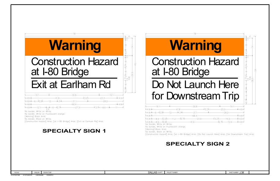
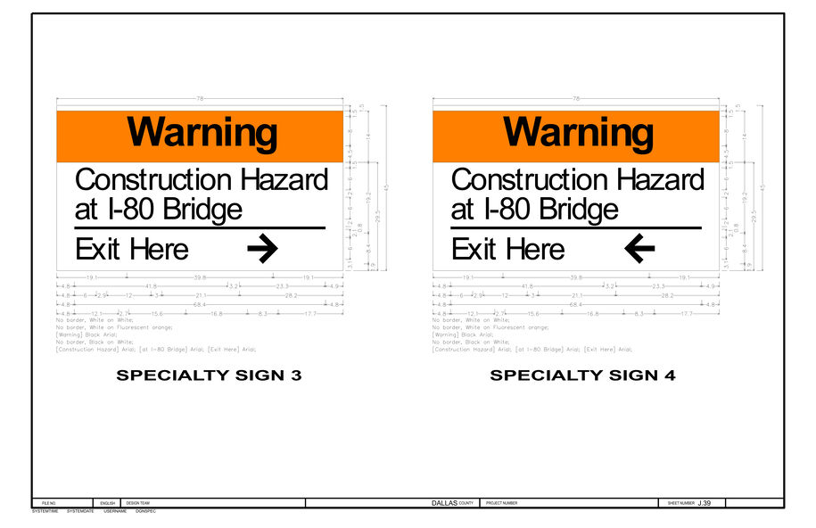
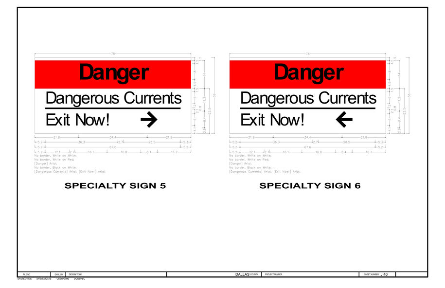
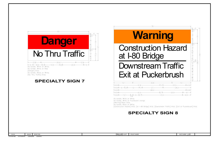
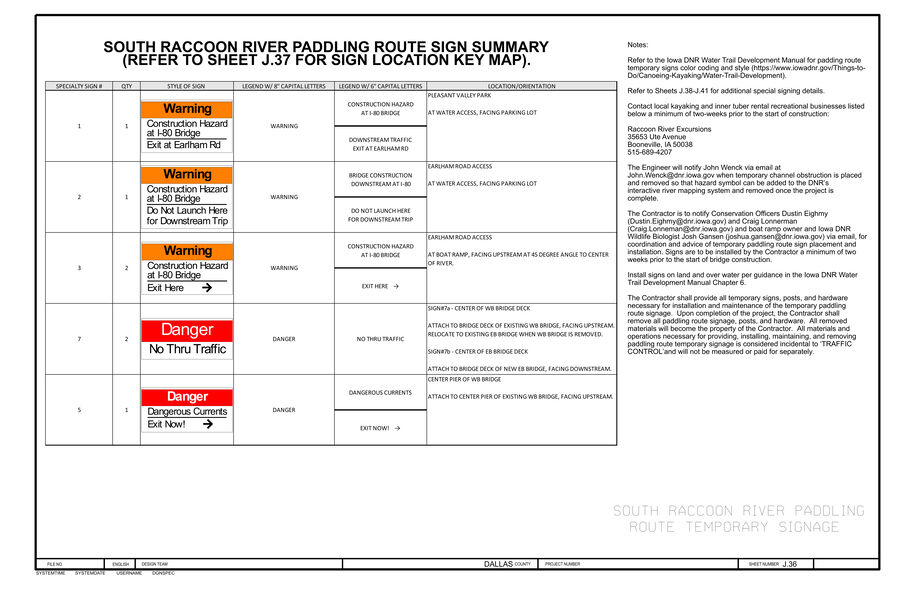
Sheet(s) showing signage fabrication details received from the Traffic and Safety Bureau.
Example sign fabrication sheet
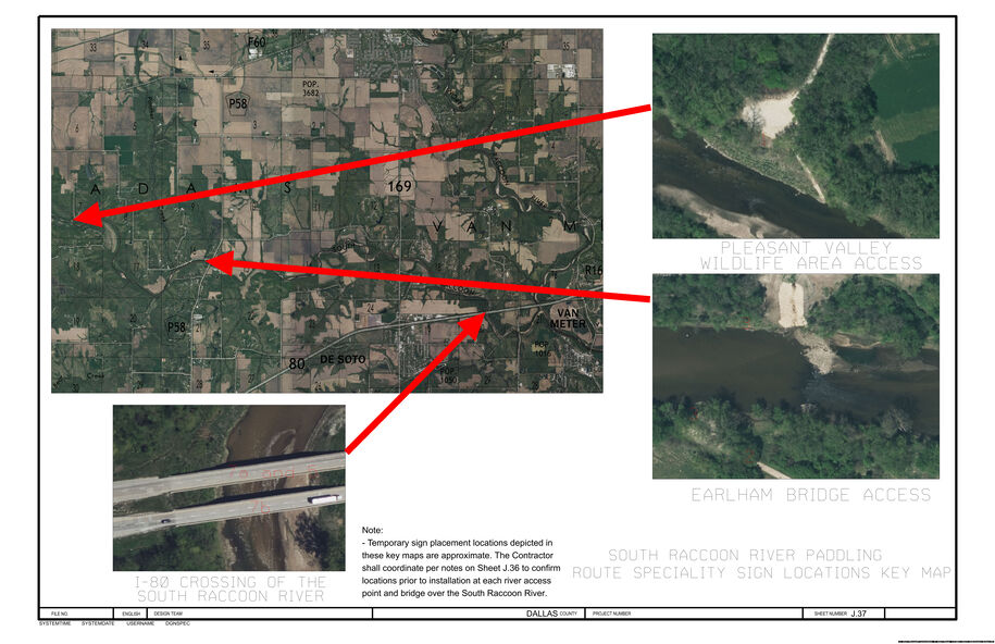
Sheet(s) showing location of advisory/warning signs for the paddle route in relation to the project on an aerial or street/waterway map provided to the designer from the Iowa DNR.
Example signage location map sheet
Sheet(s) that include notes and details that may be useful for the installation of the signs which could include but is not limited to the following:
What object or post type it will be mounted on.
Vertical offset of a point on the sign from an existing object or ground.
Distance from center of river or shoreline to the center of sign.
Angle of installed signs to a set object or the waterway.
Angle is typically 45 degrees toward center of river if for waterway traffic advanced warning signage.
At the work area, signs are typically attached to the outermost bridge beam facing upstream. If bridge beams are being removed signage will likely be installed upstream at a 45-degree angle to center of waterway.
Signs at boat launches and similar locations will need to face away from the river and towards the ramp/launch area approach.
In cases where the waterway is known to have significant fluctuations in depth throughout construction season, special notes should be included to instruct the contractor to move signage as required throughout the project or otherwise ensure signs are mounted to given object/posts in such a way as to ensure flooding will not cause signage to be damaged, lost, or at a height non-conducive to its readability.
Information Example
While not yet approved by the Iowa DNR for use, the Iowa DOT is recommending the use of flaggers (or spotters) during hazardous activities to give notice to construction crews if any waterway user approaches the work area and cease all construction activities until user is clear of the work area on the trailing end. These flaggers will be posted to allow a 60 second response time for workers to cease activities. In terms of bidding, the road designer will use the current flagger bid item and the Contracts and Specifications Bureau will dictate quantity needed in their proposal. For any plan estimates, it can be assumed 2 flaggers will be needed throughout each day of work involving any falling debris, equipment, or tool hazards.
After the sheets for the waterway(s) traffic control are assembled for the D2/D3 submittal, all waterway related sheets should be sent to the DNR contact for review. The entire plan set, including the waterway traffic control, should be sent to the usual specified people on the D2/D3 submittal letter. In the request for review email sent to the DNR, it should be requested that the DNR returns their comments no more than 6 weeks after the D2/D3 submittal or 2 weeks prior to a D4 submittal, whichever is sooner. This will allow enough time to make changes to the plans for the next submittal date.
Back to top